Do You Have A Survey and Mapping Project We Can Help With?
Cadastral Survey Services
Cadastral survey is a survey discipline that is used to measure and demarcate the land boundary of an existing land title. It can be carried out on a single lot or multiple lots. Determination of land boundary is important for land owners to ensure any development did not encroach any adjoining lots. Therefore, it is essential that a boundary survey is carried out by a qualified surveyor. This is to ensure there will not be any boundary dispute with neighbouring owners.
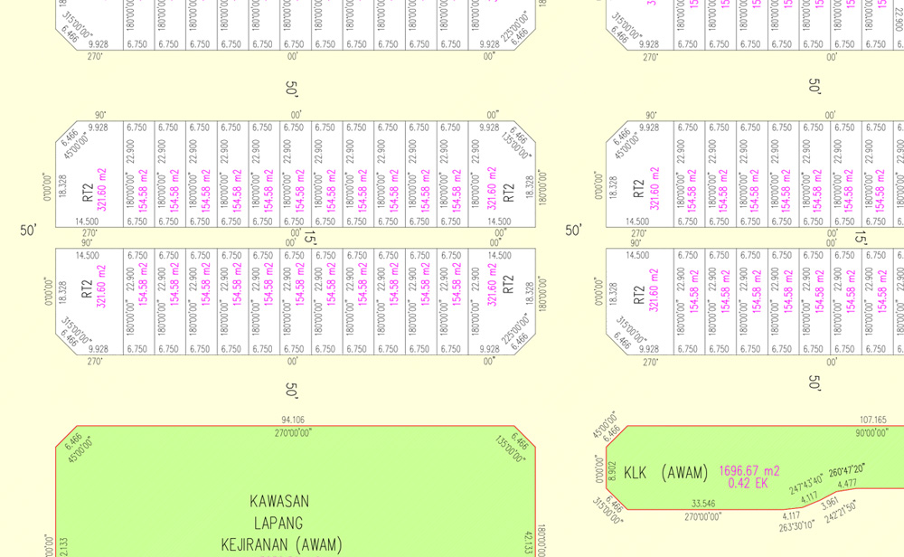
IGS Consultant also provide subdivision of an existing land title into new land title. As stipulated by the National Land Code (Act 56 of 1965) Section 137 (1), any application for subdivision of land shall be accompanied by precomputation plan. We can assist land owners to prepare the precomputation plan based on an approved layout plan for submission to the Land Office. Our staff can also provide the essential services to conduct the cadastral survey for issuance of final title in accordance with Section 396 of National Land Code (Act 56 of 1965).
IGS Consultant have the experience and qualified technical staff to conduct cadastral survey for any land boundary matters. We have completed hundreds of cadastral survey for big or small projects. We are trusted by developers such as Sime Darby Property and Perbadanan Kemajuan Negeri Selangor to conduct cadastral survey for their township development.
Strata Survey Services
Strata Title is defined as a subdivision of any building or land into parcels. High rise projects such as condominium, apartment and flat or landed property not more than four storeys can be subdivided into parcels.
Strata Titles (Amendment) Act 2013 stipulated that the Strata Plan must be prepared by a Licensed Land Surveyor. Therefore, it is essential for land owners or developers to appoint Licensed Land Surveyor for any strata title application.
IGS Consultant can assist land owners or developers in any strata title application. Our experienced technical staff are well versed with the strata title application procedures and can handle the entire process from the survey of the building to be subdivided and strata plan preparation through to submission to the relevant authorities.
Engineering Survey Services
Engineering surveys is a specialized work design specifically to meet the demands of the construction industry. IGS Consultant have provided our engineering and construction services to many disciplines such as road works, highways, bridges, pipelines, railways, high-rise buildings and residential buildings.
Our staff are well trained and have the experience to conduct any engineering and construction surveys. We used the latest survey equipment and software to perform the engineering surveys. We have provided our services to construction companies in many engineering construction projects.
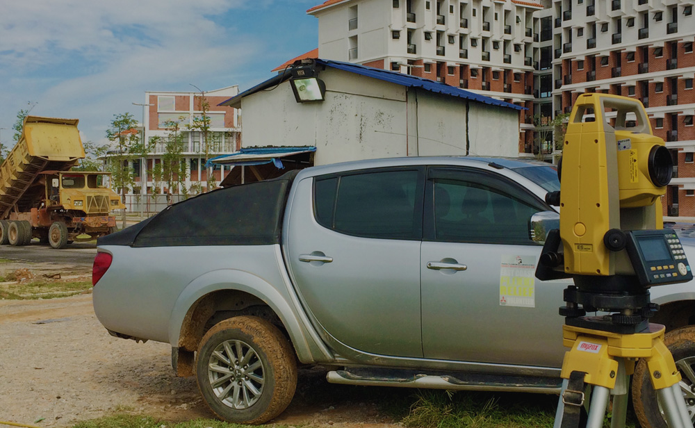
Our field surveyors have the expertise to conduct engineering and construction surveys such as establishing horizontal and vertical site control, setting-out survey for infrastructures and buildings, as-built survey of completed structures, monitoring of structures over time to detect any movement and setting out piling and footing. The deliverables at the end of the survey works can be a 2D survey plan in hard copy or digital formats such as Autocad DWG.
Our clients can rest assured that our survey works are executed in accordance with the international quality standards of the UKAS Management System ISO 9001. This will ensure clients will get consistent and quality service from us.
Topographical Survey Services
When planning for a new development, it is essential to identify the existing man made and natural features of the site and its neighbouring areas. This information needs to be captured before any design works can be carried out by town planners, architects and engineers.
Our experienced technical staff can provide topographical survey services throughout Malaysia in any type of terrain. Existing man made and natural features such as roads, houses, fences, sewer lines, manholes, vegetation, rivers and other features can be captured by our field surveyors using state of the art survey equipment. By using the latest technology in survey instrument, we can capture survey data swiftly and improving delivery times.

Once the survey data has been collected on-site, our experience technical team can produce high quality topographical and contour plans that can be provided in hard copy or digital formats such as Autocad DWG and MOSS or in any specific data format required by clients.
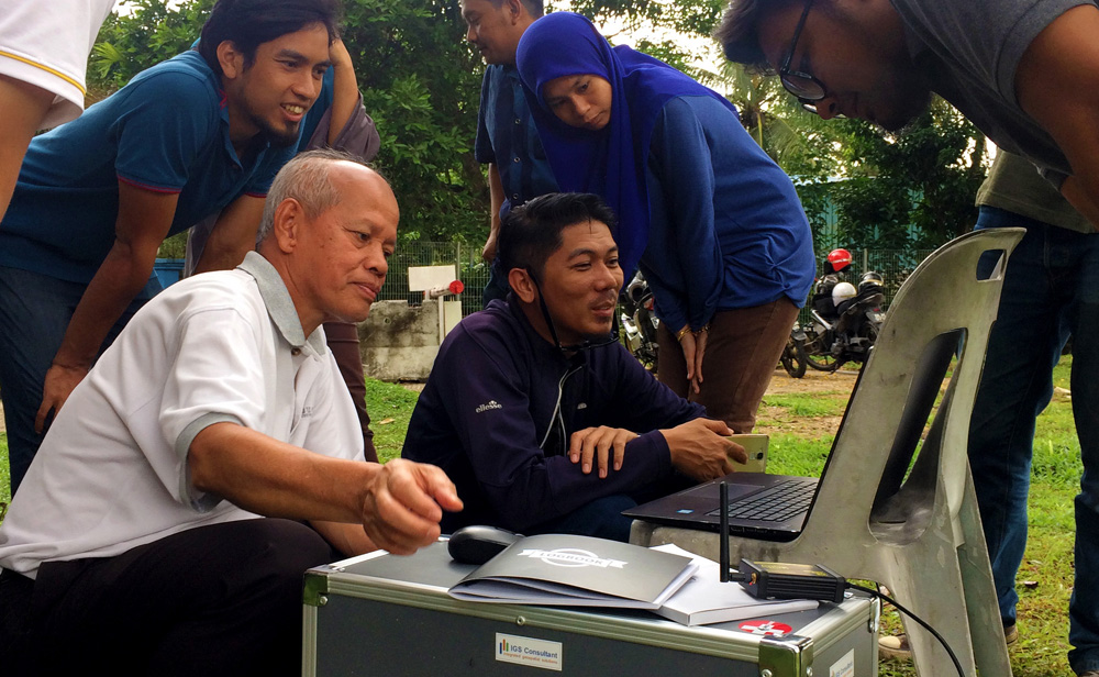
Global Positioning System (GPS) Survey Services
IGS Consultant have the experience and expertise to conduct GPS surveys for any type of applications. GPS surveys is a survey method that utilizes signals from satellite to measure a location on earth surfaces.
GPS is used in many applications such as establishing Ground Control Point for highway construction or can be used in capturing spatial data for GIS database. We can provide several types of GPS surveys such as Static GPS Survey and Real Time Kinematic Survey.
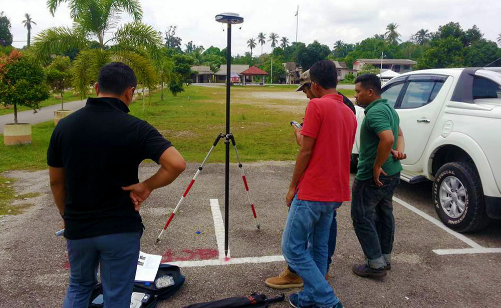
We used the latest GPS survey equipment and software to ensure we can provide the highest quality positioning data for our clients. By using state of the art GPS equipment, we are able to produce centimetre level accuracy coordinates for our clients.
Geographic Information System (GIS) Services
Geographic Information System (GIS) allows user to capture, store, analyse, retrieve and manipulate spatial data to understand relationship and trend of a spatial phenomenon. The use of GIS improves work efficiency, productivity and improved decision making by government agencies and private sectors. This will eventually enable users to save cost and time by making better decisions using GIS data.
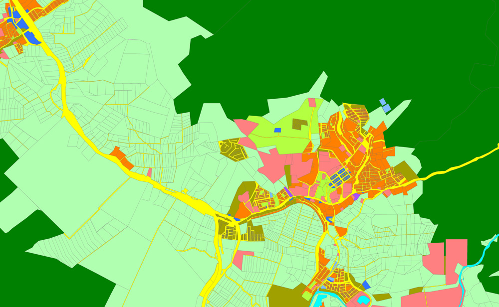
IGS Consultant have vast experience and qualified technical staff to handle large scale GIS data acquisition. We conduct GIS data collection throughout Malaysia using state of the art GIS data collection device and software. We continuously use the latest technology in GIS data acquisition to provide the best solution for our clients.
We can assist our customers to collect any spatial features and the attribute details based on user requirement. We are able to provide the GIS data in any data formats required by the customers such as shp and tab format and in any projection or coordinate system as required by the customers.
We are trusted by the state and federal agencies and private corporations to conduct GIS data acquisition for their GIS database. Some of the ever growing list of notable clients who we have work with include Jabatan Ukur dan Pemetaan Malaysia (JUPEM), TOMTOM Navigation Malaysia Sdn Bhd and Lembaga Urus Air Selangor (LUAS).
Underground Utility Survey Services
Utility lines are part of the massive infrastructure in urban areas. These utility lines are normally laid underground which may consists of several types of utility lines from different utility providers. Therefore, it is important before any excavation works being carried out, a complete identification of the existing location of the underground utility must be carried out to prevent damages to the utility lines which can lead to costly repairs. These underground utility location is also vital in the design phase of any engineering projects.
IGS Consultant used the latest equipment to identify and locate the underground utility within the survey corridor. Our staff have the expertise to conduct the underground utility survey and we have been trusted by utility service providers such as Tenaga Nasional Berhad to perform the utility survey.
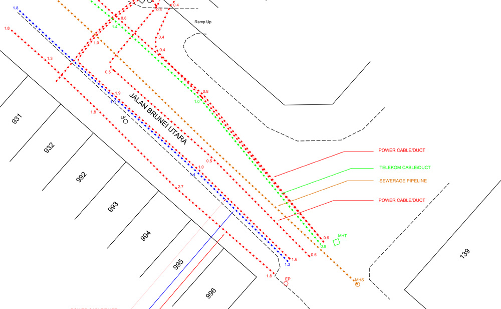
Once our staff have identified the underground utility services on-site, our technical team can produce a 2D survey utility plans in hard copy or digital formats such as Autocad DWG. IGS Consultant can also provide the location of underground utility in GIS format if required by clients.
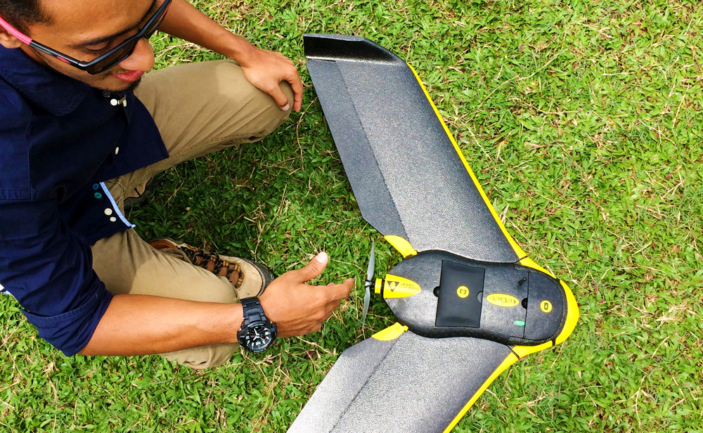
Drone / UAV Survey Services
Drone or UAV Surveys are used to capture the latest aerial imagery of the site. Drones have become an essential tool to cover large areas of inaccessible terrain quickly and accurately. It can be used in many applications such as capturing panoramic images for marketing purposes, monitoring construction progress, earthwork volume calculation, 3D modelling, mapping forest, mapping agriculture plantation areas, heritage mapping, detect illegal logging and elevation mapping.
Our professional and experienced staff have the skills to conduct drone surveys for any applications required by the clients. IGS Consultant used the latest fixed wing and multi rotor drones to capture aerial images for our clients. The aerial photos captured on-site will be processed using our state of the art software to produce orthomosaic images, 3D point clouds, 360 panoramic photos or aerial images. We can also provide Ground Control Points (GCP) using GPS to improve the absolute accuracy of the results to within 5-10cm.
IGS Consultant have conducted thousands kilometre of flights for our clients and we have the necessary experience to provide you with the latest aerial imagery. Our drones are fully compliant with the Department of Civil Aviation Malaysia (DCA) and we will handle all the necessary paperwork to apply permit from the DCA and Department Survey of Mapping Malaysia (JUPEM) before conducting the UAV surveys.
Get A Quote Today
Please fill in the form below and we’ll get in touch with you.